Updated November 14, 2025 11:51AM
2 Days in Great Smoky Mountains National Park
Only have 48 hours? Not a problem. From waterfall views to amazing hikes and firefly watching, here’s our editor-approved plan.
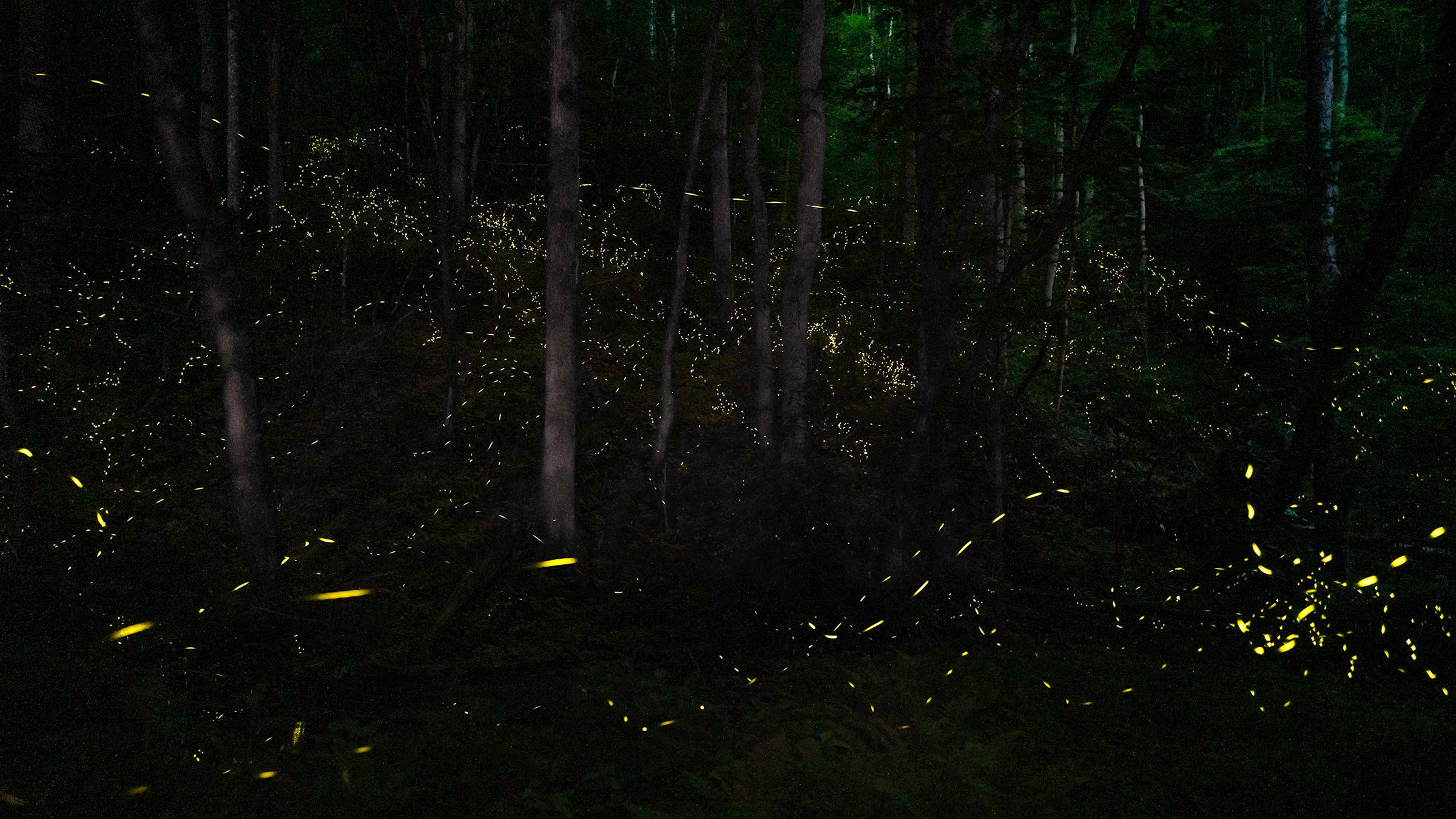
Synchronous fireflies in Great Smoky Mountains National Park (Photo: Randy Yost)
Ready to explore America’s most popular national park? Beautiful Great Smoky Mountains, full of gently rolling peaks carpeted with green trees, historic settlements, tumbling waterfalls and wildlife galore is a must visit. Stradling two states and including a segment of the famous Appalachian Trail, there’s so much to do in this park. Be strategic if you only have two days and follow our guide for the perfect weekend. From wildlife watching to bike riding and waterfall spotting, here’s our favorite way to spend two days in Great Smoky Mountains National Park.
Note: Great Smoky Mountains does not charge an entrance fee, but for those planning to stop and explore, you’ll need to buy a $5 parking tag.
Day One: North Carolina
See Elk at Cataloochee

In the summer and fall, start on the North Carolina side and wake up early to spot elk in Cataloochee Valley. In 2001, the park reintroduced the ungulates that had been missing from Great Smoky for 150 years. Today, more than 200 elk inhabit the area. Head to the meadowed areas of Cataloochee around dawn or dusk for your best chance at spotting them. Remember, bring binoculars as it’s illegal to get closer to an elk than 150 feet.
Note: Cataloochee Valley partially re-opened in April 2025 following damage from Hurricane Helene. Not all roads and trails are open. Check current conditions at nps.gov/grsm/planyourvisit/conditions.htm. Elk can also often be seen near the Oconaluftee Visitor Center.
ADVERTISEMENT
Visit the Mountain Farm Museum and Mingus Mill

Head to the Oconaluftee Visitor Center near Cherokee, North Carolina and go on a self-guided tour of the Mountain Farm Museum out back. There’s several historic buildings and educational placards to learn about the area’s past. For hundreds of years, Cherokee people farmed in the Smoky Mountains in permanent settlements. When the government forcibly removed the Cherokee, white settlers moved in, building communities that were later supported by railroads and commercial logging. Download the $1 tour booklet to get more information.

Just down the road to the north, stop at Mingus Mill, a historic gristmill built in 1886. Uniquely, it uses a water-powered turbine instead of a water wheel. In the summer, you’ll often find ranger interpretive programs as well as a miller on site grinding corn into cornmeal, which you can purchase to take home. The mill is closed for restoration work as of February 2025, but you can still walk around the building to see the impressive set up. Check for re-opening updates at nps.gov/places/mingus-mill.htm.
Drive Newfound Gap Road

The 33-mile long Newfound Gap Road (U.S. 441) bisects the park, stretching from Gatlinburg, Tennessee, to Cherokee, North Carolina with incredible views. Take a selfie with a foot in two states when you reach the Tennessee-North Carolina sign. Kuwohi is just past the “gap,” commonly referred to as “pass” in other parts of the country. The drive takes about an hour and a half, without stops. Budget more time if you plan on doing any hiking or stopping for photos (believe us, you’ll want to stop for photos). Remember, the road gains more than 4,500 feet in elevation. The weather at the top of the gap will be much cooler than in Cherokee, so dress accordingly and check road conditions at the top before setting out late fall through early spring.
ADVERTISEMENT
Hike to Andrews Bald

This short, 3.5-mile hike to the Smokies’ highest bald–a high elevation grassy meadow–is a great afternoon activity. Most of the trail remains in the shade and the higher elevation means cooler temperatures, even in the summer months. From the Kuwohi parking lot, take the Andrews Bald Trail through the forest to the bald itself where the views open up to the surrounding peaks. On a clear day, you can see all the way to Fontana Lake. June through August is a great time to hike this trail as the bald is full of blooming azaleas and rhododendrons. Look for blackberries and raspberries in this area in mid-summer, too.
Access the trailhead by parking at the end of Clingmans Dome Road via Newfound Gap Road. Long lines can occur when the parking lot fills up in the summer as visitors wait for a spot to open up. If you’re planning a hike to Andrews Bald and sunset at Kuwohi (see below) give yourself plenty of time to find a parking space.
ADVERTISEMENT
Note: This peak’s name was changed in September 2024 from Clingmans Dome, so keep an eye out for either name on signs and maps.
Catch the Sunset at Kuwohi

If you hiked Andrews Bald in the afternoon, you don’t need to move your car to stand at the highest point in Tennessee, 6,644-foot Kuwohi. Stroll just a half-mile from the parking lot along a paved path. On a clear day, you can see seven states from the overlook, which makes seeing the sunset from here all the more magnificent. Remember to bring layers, even in the summer months as temperatures can get chilly at this elevation, especially after dark.
Day Two: Tennessee
Bike or Drive the Cades Cove Loop and Have a Picnic

On Wednesdays throughout the summer, the popular 11-mile Cades Cove Loop Road closes to vehicles, allowing bikers and walkers the chance to explore this valley filled with historic buildings safely. Rent bikes from the Cades Cove Campground on a first-come, first served basis to embark on the ride. Rentals open at 7 a.m. and there’s often a queue formed before the shop opens. Get there early, or bring your coffee in a to-go mug and be prepared to wait. Note that Cades Cove is about an hour from Gatlinburg as you plan your day.

If you’re visiting on a non-Wednesday, explore Cades Cove Loop Road by car. While the loop is relatively short with the ease of a vehicle, you’ll be stopping lots to get out of the car and explore the various historic buildings including churches, log cabins, barns and a working grist mill. Cades Cove was once a vibrant community of 700 people before it became part of the national park. There’s plenty of places along the way for a picnic, from the official picnic area at the entrance of the valley, to the Cades Cove Visitor Center area, halfway through the loop. The Cades Cove store has grab and go sandwiches to make lunch easy.
Keep your eyes out for wildlife like black bears, deer and wild turkeys along the way.
ADVERTISEMENT
Drive the Roaring Fork Motor Nature Trail

This pretty scenic drive is short at just 5.5 miles, but can easily be turned into a several-hour excursion as you stop to explore pioneer homesteads and trails leading to waterfalls. In the summer the roadway is flanked by stunning green foliage and in the fall the pavement is carpeted with fallen leaves and the canopy overhead turns yellow, orange and red. Stop at Trillium Gap Trailhead to hike 3 miles to Grotto Falls or 5.4 miles to Rainbow Falls. Access the motor nature trail from Gatlinburg.
Pitch Camp at Elkmont Campground
The closest campground to the Sugarlands Entrance on the Tennessee side, this pretty spot tucked into the woods is a great place to set up camp. You’ll find tent sites and spots for RVs up to 35 feet in length here, along with flush toilets and potable water. Build a campfire in the provided fire ring and roast marshmallows, or check the schedule to see what evening programs are happening at the on-site amphitheater. Reservations can be made on Recreation.gov six months in advance.
RELATED: 7 Expert-Tested Pieces of Camping Gear You Need For the Smokies
ADVERTISEMENT
Spot Fireflies After Dark

There’s 13 species of fireflies that flash in Great Smoky and it’s common to see them in wooded areas with little undergrowth all summer long. The most famous of these is the synchronous firefly. For two to three weeks early each summer, male synchronous fireflies flash in tandem, creating a mesmerizing display where the entire forest seems to pulse in time. Viewing it is so popular, the park has created an event timed around mating season each year to view the spectacle near Elkmont Campground in late May or early June. Entry is via a very popular lottery. If you can snag a campsite during this time, you’re guaranteed access. Otherwise, try your luck at the lottery.
If you didn’t win entry, but are still visiting the park in late May or early June, take a drive on Roaring Fork Motor Nature Trail at night. Park at Trillium Gap Trailhead and walk a short distance along the path into the woods. Turn off lights and let your eyes adjust. Between 9:30 and midnight is the prime time to catch the synchronous show–it’s not as impressive as the Elkmont viewing, but still well worth the trip. At other times throughout the summer, head to a wooded area with little undergrowth, preferably near water at full darkness, and keep your eyes peeled for flashes.
ADVERTISEMENT
Looking for more national park fun? Drive the stunning Blue Ridge Parkway.


